Spend enough time diving the Great Barrier Reef and you develop a particular kind of tunnel vision. Your attention narrows to the immediate patch of coral in front of you, the fish moving through the water, the texture of the reef wall dropping away below. You see detail. You see color. You see individual polyps and the way light refracts through the water column. What you don’t see is the reef itself – the massive, interconnected system stretching across 1,400 kilometers of Australia’s northeast coast. That perspective only becomes clear when you step back far enough. And stepping back far enough means leaving the water entirely.
Satellite imagery has fundamentally altered how scientists understand the Great Barrier Reef’s structure and health. The view from space reveals patterns that would take a diver weeks of underwater exploration to piece together, and even then only as fragmentary observations. Satellites capture the reef’s geometry, its color variations, its bleaching patterns, and its response to environmental stress in ways that ground-level observation simply cannot match. This isn’t supplementary information. For understanding the reef at scale, satellite data has become essential.
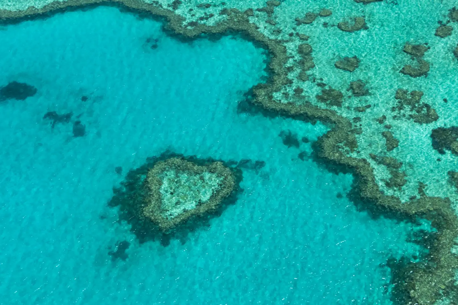
The Geometry Divers Miss
When you’re underwater on the reef, you experience it as a three-dimensional maze of coral formations, channels, and drop-offs. The navigation feels organic and spatial. You move through it, around it, over it. But you’re moving through a tiny fraction of a much larger system whose overall shape and organization remain invisible from your position within it.
Satellite imagery reveals the reef’s architecture with striking clarity. The Great Barrier Reef isn’t a continuous wall. It’s composed of distinct reef systems separated by channels and gaps. Some sections run parallel to the coast. Others angle away from it. The spacing between individual reefs follows patterns that aren’t obvious when you’re diving one isolated section. Satellites can map these relationships in a single image. They show how water flows between reefs, where currents likely concentrate, and how the reef’s structure creates natural corridors for fish movement and larval dispersal.
This structural information matters practically. It helps researchers understand where fish populations concentrate, how disease might spread through the reef system, and where conservation efforts should focus. It also reveals that the reef’s organization isn’t random. The spacing and orientation of individual reef systems reflect responses to wave action, water depth, and historical growth patterns. Understanding this geometry changes how scientists think about the reef’s resilience and its capacity to recover from damage.
Check real traveller reviews, prices, availability, departure points, and flexible booking options in one place.
Color Tells Stories Satellites Can Read
Underwater, coral color is affected by water depth, light absorption, and the angle of your dive light. A coral that appears brown at 20 meters might look different at 10 meters. The same coral photographed in morning light versus afternoon light registers differently. Your eye adapts to the blue-green filtered light of the underwater environment. After an hour of diving, your color perception shifts. You stop noticing how muted the reds have become.
Satellites measure the actual wavelengths of light reflecting from the reef. They don’t rely on human perception or adapt to underwater conditions. Different types of coral, different algae, and different levels of coral health reflect light at distinct wavelengths. Healthy coral reflects certain color signatures. Bleached coral reflects others. Algae-covered reef reflects yet another pattern. Satellites equipped with multispectral sensors can distinguish these differences across the entire reef system simultaneously.
This capability has proven crucial for monitoring coral bleaching events. When water temperatures spike, corals expel their symbiotic algae and turn white. From a boat or while diving, you see individual bleached colonies. Satellites see the bleaching event as a landscape-scale phenomenon. They can map which reefs bleached, which ones recovered, and which ones experienced repeated bleaching stress. The 2016 bleaching event that devastated large sections of the reef was documented in detail through satellite monitoring. Divers saw the damage in specific locations. Satellites showed the damage’s full extent and spatial distribution.
Temporal Patterns Only Time-Lapse Reveals
A single dive captures a moment. Even a week of diving captures only a narrow window of observation. Seasonal changes, year-to-year variations, and long-term trends remain invisible to individual divers. Satellites, by contrast, have been observing the reef continuously for decades. Modern satellite systems can image the same location multiple times per week, sometimes multiple times per day.
This temporal coverage reveals patterns that ground-based observation struggles to detect. Researchers have used satellite data to track how the reef responds to seasonal temperature changes, how sediment plumes from coastal rivers affect different reef sections, and how recovery progresses after bleaching events. They’ve identified that some reef sections show consistent resilience while others degrade more rapidly. They’ve documented that recovery isn’t uniform – some areas bounce back quickly while others stagnate for years.
The timing of observations matters too. Satellites can image the reef during conditions when diving would be impossible or dangerous. Rough seas, strong currents, and poor visibility that keep divers on the boat don’t prevent satellite observation. This means researchers capture data during the reef’s full range of conditions, not just the calm days when diving is feasible.
What Divers Experience That Satellites Cannot
The advantage swings the other direction when it comes to biological detail and ecosystem dynamics. Satellites cannot identify individual fish species or count the number of fish in a given area. They cannot assess the health of a coral colony by looking at polyp extension or tissue condition. They cannot detect the subtle behavioral changes that indicate stress or disease. They cannot measure water temperature with the precision that underwater thermometers provide.
A diver can spend an hour observing a single reef section and gather qualitative information about fish behavior, coral condition, and ecosystem function that no satellite could extract. Divers can notice that fish are avoiding certain areas, that some corals are covered in algae while others remain clean, that the reef feels less vibrant than it did in previous years. These observations are subjective but valuable. They provide ground-truth data that helps interpret satellite imagery and validate what the data suggests.
The most effective reef monitoring combines both approaches. Satellites provide the broad-scale, temporal view. Divers provide the detailed, qualitative assessment. Together, they create a more complete picture than either method alone can achieve.
The Scale Problem Satellites Solve
The Great Barrier Reef covers an area roughly equivalent to Italy. Monitoring that entire system through diving alone would require hundreds of divers working continuously for months. Even then, the coverage would be patchy and incomplete. Satellites can image the entire reef in a matter of hours. They provide consistent, systematic coverage that ground-based monitoring cannot match.
This scale advantage has practical implications for conservation and management. Reef managers need to know which sections are degrading fastest, where intervention might be most effective, and how the reef system as a whole is responding to climate change and other stressors. Satellite data provides this information at a scale that makes strategic planning possible. Without satellite monitoring, reef management would rely on fragmentary observations and educated guesses about conditions in areas that haven’t been recently visited.
The integration of satellite data into reef science has also changed how scientists think about the reef’s future. Long-term satellite records show clear trends in bleaching frequency, recovery rates, and overall reef health. These trends are difficult to detect from individual dives or even from a diver’s cumulative experience. They require the kind of systematic, long-term observation that only satellites can provide.
Spending time underwater on the reef creates an intimate understanding of what the reef is. Satellite imagery creates an understanding of what the reef does at scales that human presence cannot reach. Neither perspective is complete without the other. The divers see the reef as an intricate, living system full of detail and complexity. The satellites see the reef as a dynamic landscape responding to forces and stresses that play out across seasons and years. Together, these views tell a more honest story about one of the ocean’s most remarkable ecosystems.
Compare top-rated tours, prices, availability, and real traveller reviews before booking. See what’s actually available for your dates and departure location.
Compare tours and check availability