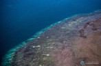


DNA reveals the past and future of coral reefs
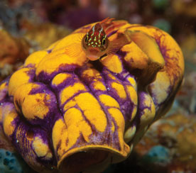
New DNA techniques are being used to understand how coral reacted to the end of the last ice age in order to better predict how they will cope with current changes to the climate. James Cook Univer
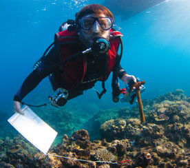
From 2005 to 2022, the main node of the ARC Centre of Excellence for Coral Reef Studies was headquartered at James Cook University in Townsville, Queensland (Australia)
Abstract: The map is a powerful medium for effectively communicating a large amount of often complex spatial data in an efficient and attractive manner. For the past few centuries the making of maps has been underlain by a scientific worldview, with an overriding imperative for accuracy and objectivity. However, the potential of personal narrative and art to complement science-led maps is now being recognised as a way of representing social and individual geographic phenomena. These alternative representations affect the viewer in a more impactful and emotional way, providing a more personal channel of spatial communication that often suits grassroots and community initiatives as well as public dissemination. This presentation will visit two case studies. One is a project that captured the local knowledge of experienced members of the Bluff oyster fishery, New Zealand, to empower their point of view – a fishery under critical stress. This was an informal mapping exercise of grounds fished over the decades – a personal spatial narrative. Some ways of representing this data, both with and without the nearest equivalent scientific data representation are explored. The second case study is a collaboration with a local artist to build an interactive art-map interface of the history of the kea, the alpine parrot endemic to the South Island of New Zealand. Both case studies also demonstrate spatial data that changes through time and the power of art in particular to address this will be considered.
Biography: Antoni Moore is a senior lecturer in Geographical Information Science (GIS) at the National School of Surveying, University of Otago. His current research interests focus on geovisualisation and cartography, including visual representation using art, narrative and informal mapping as a complement to conventional mapping. He is the coordinator of the GIS applied science degrees and postgraduate diploma (BAppSc, MAppSc, PGDipAppSc) at Otago and is currently secretary of the New Zealand Cartographic Society. His academic training was in the UK, in GIS and geography, with a PhD in Geographical Information Science from the University of Plymouth, MSc degree in Geographical Information Systems from the University of Leicester and a BSc(Hons) in Geographical Science from the University of Portsmouth. He was previously a lecturer in Otago’s Department of Information Science from 2001-2007 and before that a coastal GIS Analyst at Plymouth Marine Laboratory in the UK.
New DNA techniques are being used to understand how coral reacted to the end of the last ice age in order to better predict how they will cope with current changes to the climate. James Cook Univer
A new study on the effects of climate change in five tropical countries has found fisheries are in more trouble than agriculture, and poor people are in the most danger. Distinguished Profess
James Cook University researchers have found brightly coloured fish are becoming increasingly rare as coral declines, with the phenomenon likely to get worse in the future. Christopher Hemingson, a
Researchers working with stakeholders in the Great Barrier Reef region have come up with ideas on how groups responsible for looking after the reef can operate more effectively when the next bleaching
Abstract: As marine species adapt to climate change, their heat tolerance will likely be under strong selection. Individual variation in heat tolerance and its heritability underpin the potential fo
Abstract: The Reef Ecology Lab in KAUST’s Red Sea Research Center explores many aspects of movement ecology of marine organisms, ranging from adult migrations to intergenerational larval dispersal
Abstract: Macroalgal meadows are a prominent, yet often maligned component of the tropical seascape. Our work at Ningaloo reef in WA demonstrate that canopy forming macroalgae provide habitat for ad
Abstract: Sharks are generally perceived as strong and fearsome animals. With fossils dating back at least 420 million years, sharks are not only majestic top predators but they also outlived dinosa
Abstract: Connectivity plays a vital role in many ecosystems through its effects on fundamental ecological and evolutionary processes. Its consequences for populations and metapopulations have been
Abstract: Evolution of many eukaryotic organisms is affected by interactions with microbes. Microbial symbioses can ultimately reflect host’s diet, habitat range, and even body shape. However, how
Abstract: The past few years have seen unprecedented coral bleaching and mortality on the Great Barrier Reef (GBR) but the consequences of this on biodiversity are not yet known. This talk will expl
Partner Research Institutions